Detection of “El Niño” Effect at the Roque de
los Muchachos Observatory?
Javier Méndez
* (ING) and Sergio Suárez (Asociación Canaria
de Meteorología)
El Niño
happens when tropical Pacific Ocean trade winds die out and ocean temperatures
become unusually warm. There is a flip side to El Niño called La Niña,
which occurs when the trade winds blow unusually hard and the sea temperature
become colder than normal. El Niño and La Niña are the warm
and cold phases of an oscillation referred to as El Niño/Southern
Oscillation, or ENSO. Although ENSO originates in the tropical Pacific ocean-atmosphere
system, it has effects on patterns of weather variability all over the world.
It is believed, for instance, that El Niño conditions suppress the
development of tropical storms and hurricanes in the Atlantic, and that La
Niña favors hurricane formation.
The index used to monitor the coupled oceanic-atmospheric character of ENSO
is called the Multivariate ENSO Index (MEI) based on the main observed variables
over the tropical Pacific. The MEI can be understood as a weighted average
of the main ENSO features contained in the following six variables: sea-level
pressure, the east-west and north-south components of the surface wind, sea
surface temperature, surface air temperature, and total amount of cloudiness.
Positive values of the MEI represent the warm ENSO phase (El Niño).
On the William Herschel Telescope weather observing downtime is recorded
by observers when the following happens: humidity is higher than 90%, mirror
temperature is less than 2 degrees of the dew point, wind speed is higher
than 80 km/h (or gusts for more than 10 seconds are above 80 km/h), dust
is clearly visible in the beam of a torch, or if the dome shows any resistance
to movement due to the presence of ice.
In spite of the inaccuracies present in the process of recording weather
downtime, and the fact that several elements contribute to the downtime apart
from rain, it is possible to see some teleconnection between the MEI index
and the percentage of weather downtime as it is shown in the accompanying
plots. A study of rainfall and MEI carried out at Teide Observatory on Tenerife
(Sergio Suárez Izquierdo, 2003, “Relaciones observadas entre el fenómeno
de “El Niño” y las precipitaciones en la isla de Tenerife”, I Encuentro
sobre Meteorología y Atmósfera de Canarias, DG-INM, November
2003, p. 51.) came to a similar conclusion.
¤
|
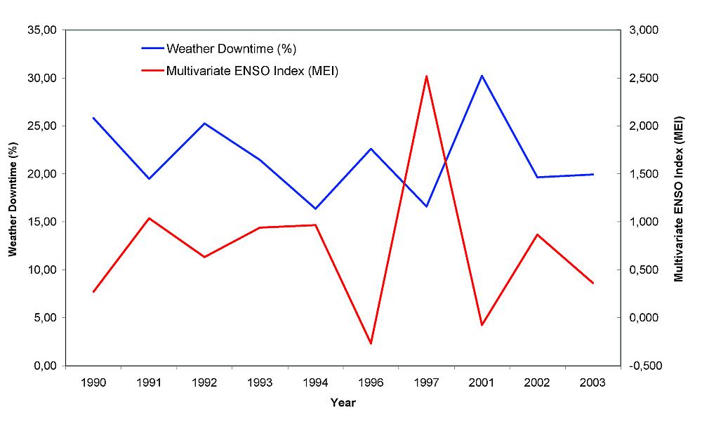
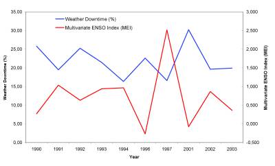
| Comparison between the percentage of weather observing
downtime at the William Herschel Telescope and the Multivariate ENSO Index
(MEI) averaged from June to December inclusive (when the highest correlation
is found). Only the episodes with averaged MEI positive in the period June-May
are considered, ie. when the El Niño effect took place in the interannual
period June-May then we averaged weather downtime and MEI index for the corresponding
period June-December. [ JPEG | TIFF ]
|
|
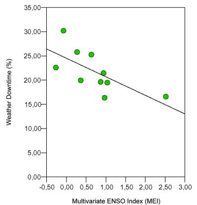
| Same data as before. Correlation of linear regresion
is r=–68 or confidence level of 95%. [ JPEG |
TIFF ]
|
*Email contact: Javier
Méndez (
jma@ing.iac.es)