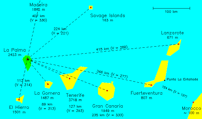
The map above shows the relative locations of the 7 main Canary Islands (which are part of Spain), Madeira (Portugal), the Savage Islands (Portugal), and the African coastline.
The approximate position of the highest peak on each island is indicated by a red dot, and its height is given in m. The red dot on the African coast indicates the closest point to the Canaries, near the border between Morocco and Western Sahara, and the quoted height of ~ 100 m is representative of land not far from the coast.
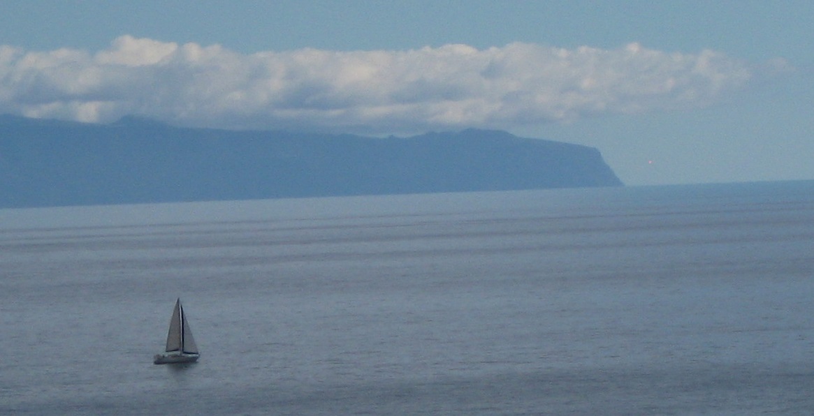
The view from La Palma (mountain-top)
Each dashed line on the map shows a line of sight from the peak
on La Palma to the peak of another island,
with the separation given in km.
The map also shows the visibility range V, i.e. the maximum distance in km
at which one peak will be visible from the other, taking into account
the curvature of the earth's surface. A formula for calculating
V is given at the end of this page.
If V is greater than the actual distance between the peaks, it should be possible to see one peak from the other.
Tenerife, La Gomera and El Hierro are thus easily visible from the mountain-top on La Palma on most days. Gran Canaria would also be visible if it didn't lie behind Tenerife.
Fuerteventura, Lanzarote, Madeira and Africa are too far away and/or too low-lying to be seen from La Palma, and the same is probably true of the tiny Savage Islands (Ilhas Selvagens in Portuguese, Islas Salvajes in Spanish).
Clouds forming above Madeira or the Savage Islands might occasionally be visible from La Palma, but I know of no reports of this. For people interested in hunting for such clouds, it's helpful to know that from the summit of La Palma, Madeira lies in a direction almost exactly opposite to that of El Hierro, while the Savage Islands lie in a direction almost exactly 90 deg North (i.e. left) of the direction to La Gomera.
The view from La Palma (sea level)
From Santa Cruz on La Palma, Tenerife and La Gomera are usually visible to the south east. The lower parts of both islands are hidden from view by the curvature of the earth's surface. E.g. from a height ~ 0 m above sea level on La Palma, only elevations above ~ 620 m on Tenerife, and above ~ 400 m on La Gomera, can be seen.
These numbers change with increasing height of the viewpoint in Santa Cruz. From a height of ~ 30 m, for example, one should be able to see down to elevations ~ 400 m on Tenerife and ~ 200 m on La Gomera.
And from the hills around Santa Cruz de La Palma at a height ~ 300 m, elevations above ~ 100 m can be seen on Tenerife, and on La Gomera, the view extends down almost down to sea level.
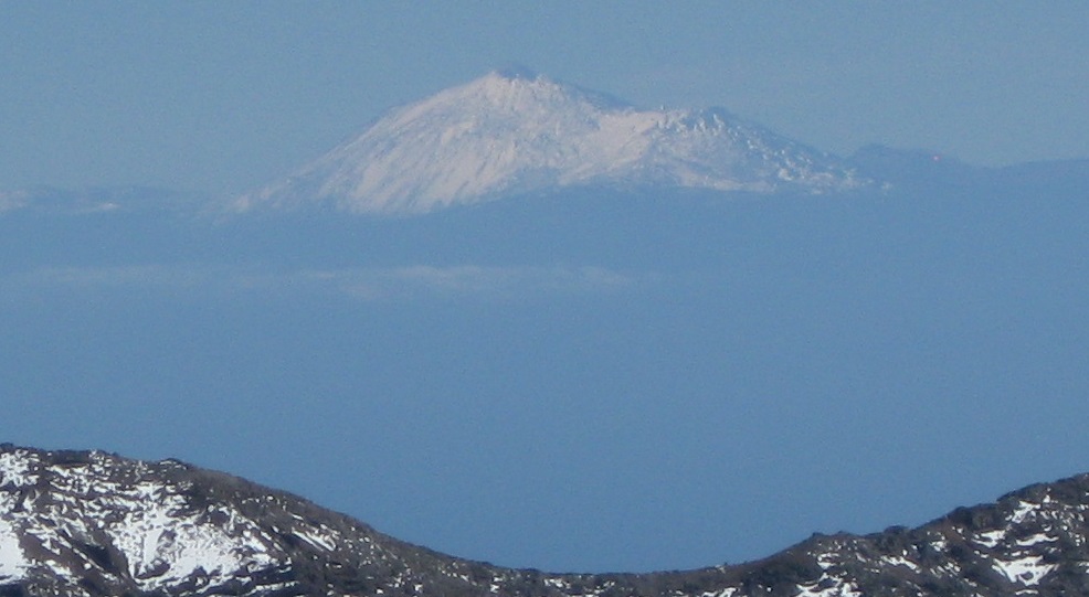
The view from Tenerife
It's said that on a clear day, all of the Canary Islands are visible
from the 3718-m peak of Tenerife (Mt Teide).
Lanzarote's peak is the most distant,
~ 312 km from Mt Teide, and this is similar to
the visibility range
V ~ 310 km, so indeed these two peaks may just be visible to
each other in good conditions. The Savage Islands may also be visible
from Mt Teide.
What about other, more distant peaks? The Cape Verde Islands (to the south-west), the Azores (to the north-west) and the Atlas Mountains in Morocco (to the north-east, peak ~ 3600 m) are all too far away (1500, 1500 and 900 km respectively) to be visible from any of the Canary Islands.
The African coast lies only ~ 313 km from Mt Teide, but this is greater than the visibility range V ~ 253 km.
The view from Fuerteventura
There are reports of Africa being visible from Fuerteventura.
The African coast lies 124 km from the highest point on Fuerteventura,
Pico de La Zarza,
and 97 km from the closest point on Fuerteventura, Punta La Entallada.
Assuming a height of ~ 100 m for land near the Moroccan coast
(there are no mountains close to the coast),
the predicted visibility ranges are 137 km from Pico de La Zarza
and ~ 90 km from Punta La Entallada (and ~ 100 km from a peak just inland
of Punta La Entallada). Africa should therefore be
visible from at least Pico de La Zarza, on a clear day.
It's also said that Africa is sometimes visible from sea level on the Fuerteventura coast, and this might be detection of cloud or dust storms at an elevation of e.g. a few hundred m above Morocco.
The view from the air
From a flying height ~ 8 km, say, the visibility range for low-lying
land is ~ 320 km.
From this flying height, the peaks of Tenerife and La Palma should be visible from ~ 500 km away.
Formula for visibility range V
On the surface of a spherical planet of diameter D km,
a peak of height H1 km
will just be visible from a peak of height H2 km
at a horizontal distance of approximately:
V (km) ~ √D * (√H1 + √H2)
which for planet earth is:
V (km) ~ 113 * (√H1 + √H2) assuming that H1 amd H2 are much smaller than the diameter of the planet.
In the above calculation, no account is taken of the effect of the earth's atmosphere. On the one hand, the range of visibility near the horizon may be limited by cloud or by dust (e.g. Saharan dust, which sometimes affects the islands). On the other hand, the range of visibility may be extended by refraction (which has a small effect and is not currently included here) and mirage conditions. Also, the location of an island can be given away by the presence of cloud which forms above an island peak, and which is therefore visible to larger distances than the peak itself.
The approximate inter-peak distances for the Canary Islands are compared with the visibility ranges (V in km) below. Sightlines where one peak should be visible from another (in the absence of any intervening islands) are highlighted in yellow. Sightlines for which distance and calculated V differ by < 10% (i.e. the peaks may be mutually visible) are highlighted in pink. For the remaining (i.e. not highlighted) sightlines, the distance is too great for one peak to be seen from another.
| El Hierro | La Gomera | Tenerife | G. Canaria | F'ventura | Lanzarote | Madeira | Savage I. | Africa | |
|---|---|---|---|---|---|---|---|---|---|
| 113 km V = 314 | 89 km V = 313 | 127 km V = 393 | 235 km V = 333 | 346 km V = 277 | 415 km V = 268 | 407 km V = 330 | 224 km V = 221 | 468 km V = 212 | La Palma |
| | 90 km V = 276 | 150 km V = 356 | 242 km V = 296 | 363 km V = 240 | 461 km V = 231 | 520 km V = 292 | 320 km V = 184 | 476 km V = 174 | El Hierro |
| | | 61 km V = 355 | 163 km V = 295 | 282 km V = 239 | 373 km V = 230 | 467 km V = 292 | 240 km V = 183 | 400 km V = 173 | La Gomera |
| | | | 108 km V = 375 | 224 km V = 319 | 312 km V = 310 | 452 km V = 372 | 203 km V = 263 | 344 km V = 253 | Tenerife |
| | | | | 121 km V = 259 | 233 km V = 250 | 502 km V = 312 | 232 km V = 203 | 237 km V = 193 | Gran Canaria |
| | | | | | 135 km V = 194 | 532 km V = 255 | 269 km V = 147 | 124 km V = 137 | Fuerteventura |
| | | | | | | 484 km V = 246 | 260 km V = 138 | 164 km V = 128 | Lanzarote |
| | | | | | | | 271 km V = 200 | 633 km V = 190 | Madeira |
| | | | | | | | | 382 km V = 81 | Savage Islands |
For the highest point on earth, Mt Everest (8850 m), the formula predicts a maximum visibility range, to low elevations, ~ 340 km. The world's longest sight-line is reputed to be ~ 500 km, between mountain peaks in Kyrgyzstan and China.
For similar calculations on other planets, replace the 113 in the formula above by the square root of the diameter of the planet in km. If the earth were the size of the moon, for example (but with the heights of the islands and sea as they are now) the visibility ranges V would be a factor of ~ 2 smaller, and although Tenerife, La Gomera and El Hierro would still be visible from the mountaintop on La Palma, they would not be visible from sea level.
Thanks to Richard Ashley for drawing my attention to a couple of errors in the original calculations.
Back to Chris Benn's home page.
Chris Benn
(crb@ing.iac.es)
Last revised 19 August 2020